


• Hortwatch
• Property Maps
|
Home
| |
|
Monitoring | |
|
Soil moisture | |
|
Fruit size | |
|
Pest & Disease
| |
|
Other Services | |
|
Sprayer calibration | |
|
Property mapping | |
|
Consultancy
| |
|
The Library | |
|
Articles from our consultants
| |
|
Tools | |
|
Downloadable tools for growers
| |
Property Maps | |
|
An essential tool for orchard planning. Using a scaled aerial photograph, your property can be mapped to give you the grower, your staff, contractors and suppliers a clear visual reference to work from. As simple or as detailed as you like, your map can identify:
Sample Orchard Map
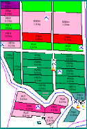
View sample map
Want to know more? Email Deanna at deanna.corbett@agfirst.co.nz or phone (06) 872 7080 to discuss your needs. | |
|
 Hortwatch® is a product of AgFirst Phone: 64 6 872 7080 Fax: 64 6 870 3629 email: agfirst@hortwatch.com |